702 Schijenfluh Umrundung, naturkundlicher Alpenrundweg


Show all 13 images

Cross-border, natural history circumnavigation of the Schijenfluh.
Details
Description
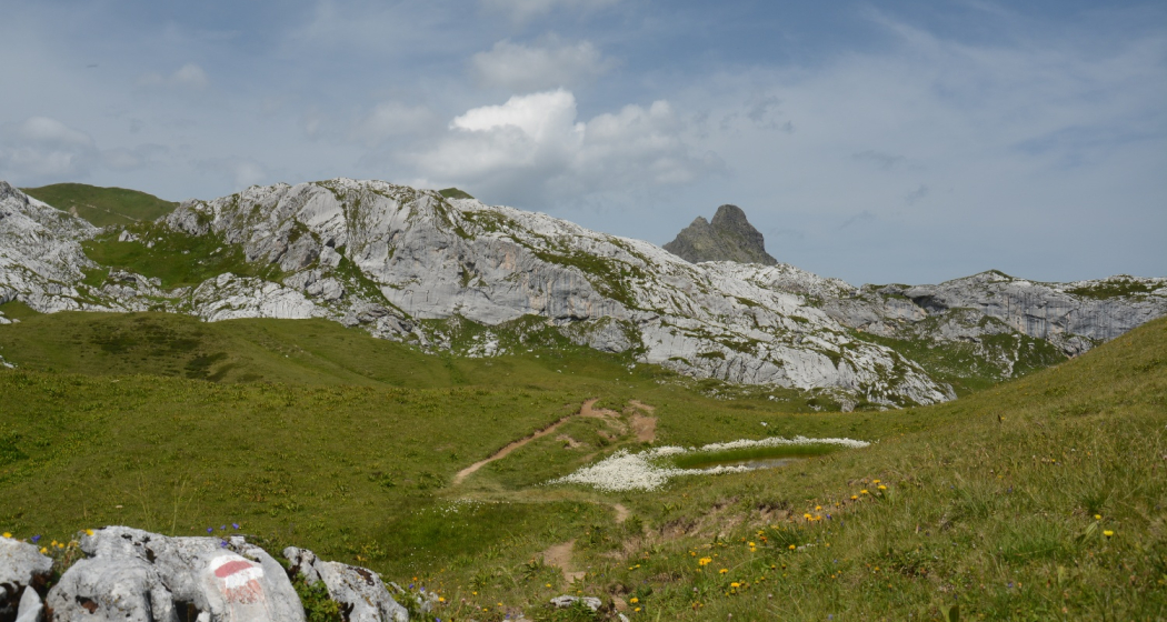
The circuit begins in Partnunstafel at the foot of the Schijenflue, at the far end of the St. Antöniertal valley, a side valley of the Prättigau. Hiking past alpine pastures and over dwarf shrub heathland we soon make our way up to the emerald-green waters of the Partnunsee lake. Surrounded by the sheer limestone walls of the Sulzfluh and Schijenflue the mountain trail takes us through a stunning limestone landscape up to the Tilisunafürggli, the «green border» with Austria. Here the landscape turns into a hilly grassy high-alpine valley where alpine cattle graze in summer. After a short detour to the Tilisuna hut we continue on our way along a gentle up-and-down section, past small lakes and one or two customs huts, then over the Gruoben Pass to the highest point of our hike, the Plasseggen Pass (2354 m), which also forms the state border with Switzerland.
Dark mountain ranges of crystalline Silvretta rock on one side of the valley contrast sharply with the lighter limestone massif on the other. After passing the Plasseggen hut we find ourselves on a short and very steep section that zigzags its way downhill. The views gradually open up as we make our way through dwarf shrub heathland and across lush alpine meadows back to the Partnunstafel, where two mountain restaurants offer some welcome hospitality.
Geheimtipp
Take the scooter from the mountain houses to St. Antönien Platz or the starting point of the tour. Fun end to a wonderful tour!
Sicherheitshinweis
On high-altitude sections, snowfields are possible until the summer months. When climbing from Lake Partnunsee, sure-footedness is required. The scree path and short passages on sanded limestone cliffs are often slippery, especially in damp weather. From Tilisunafürggli keep left to tilisunahütte (no signalling).
In the opposite direction, a head for heights is required in the descent towards Lake Partnunsee above "Tritt" (2044 m).
Directions
The starting point of the round trip is Partnunstafel (1763 m) at the foot of the Schijenflue, at the back of the St. Antöniertal, a side valley of the Prättigau. After a short ascent in the direction of the Tilisuna hut, you reach the emerald green Partnunsee, which invites you to go boating or take a refreshing dip. From here, the scree path first climbs gently and, after the "Tritt" (2044 m), crosses an imposing, grey-rocky cart landscape. On the left rise the rock faces of the Sulzfluh with their climbing opportunities and the Sulzfluh caves, which were once inhabited by cave bears, while to the right of the path rise the limestone walls of the Schijenflue. Further up, the path branches off to the left to Tilisunafürggli, the "green border" to Austria. From here, the landscape turns into a hilly landscape overgrown with short grass, which accompanies us from now on. Keeping to the left, after a short descent you reach one of the oldest huts in the Rätikon, the Tilisunahütte (2208 m). Below it, Lake Tilisuna shines deep blue. After a short ascent to the Gruoben Pass, the path leads gently up and down towards the Plasseggen Pass. On the left, the high valley is bordered by the dark mountains of the Platinaköpfe, Sarotlaspitzen and Röbispitzen, while on the right it is framed by the grey cart fields of the Wiss-Platte and Schijenflue. Shortly before reaching the Plasseggen Pass, you pass a stone customs hut. At the Plasseggen Pass (2354 m), the highest point of the hike, you cross the border with Switzerland again. The path across the wide grassland leads gently downhill, past the Plasseggenhütte, a shepherd's hut. Shortly afterwards, a short, very steep passage zigzags downhill over a scree path to a fork in the road. Here it goes abruptly to the right under the rocks and past "Weberlisch Höli". Old characters and numbers written with "red chalk" can still be seen on the rock face. The view towards Partnunstafel and the valley widens and over dwarf shrub heathland and lush alpine meadows, the path leads back to the starting point of the hike to Partnunstafel, where you can end the tour in the Berghaus Sulzfluh or Alpenrösli. From here there is also the possibility to end the last few meters back to the car park with a scooter ride.
Directions
Public Transport
Take the Rhaetian Railway RhB to Küblis, then take the PostBus to St. Antönien, last stop Sagaris (July – October). Timetable field 90.222. On the hiking trail walk about 1/2 hour left from the Schanielabach to Partnunstafel or take the Bus alpin (reservation required) to Partnun.
Anreise Information
Parking
In St. Antönien, all parking spaces are subject to a fee. In the car parks, you can pay with cash, the Parkingpay app or Twint. The last parking lot P6 with day ticket is located below the Partnunstafel, about 3.5 km outside of St. Antönien.
Responsible for this content: SwitzerlandMobility.
This content has been translated automatically.
